The rapid changes to the Elwha nearshore are both exciting and inspiring. The Coastal Watershed Institute has been monitoring the ecological function of the Elwha nearshore for over a decade, including both pre-dam removal and dam removal timelines. We presented some of our preliminary observations of nearshore response to dam removal at the Salish Sea Conference held in Seattle April 20 – May 2 2014. Dam removal is still in full swing so everything is very much in flux both physically and ecologically. With that caveat, the presentation summarized highlights of our observations of juvenile fish use of the Elwha estuary. In the spirit of the conference’s emphasis on shared ecosystem responsibility, this post includes much of the material covered in the presentation.
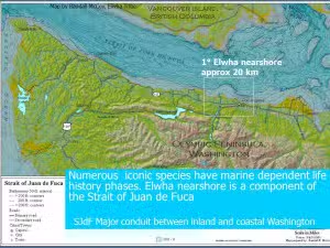
The Elwha nearshore is a part of the Strait of Juan de Fuca, the major conduit between inland and coastal ecosystems. Legislation from 1992 cleared the way for dam removal on the Elwha River -the enabling legislation stipulated the restoration of the Elwha ecosystem-which includes nearshore….
Will dam removal make a difference for native salmon? The answer is a resounding yes. A comparasion of successful spawning adult salmon numbers after dams were installed (the 2005 data) and an estimate of pre dam spawning numbers reveal dramatic-but not unexpected-declines in fish use which are due to dams.
Note that prior to dams, chum and pink were a dominant salmon in the Elwha system. After dams were installed? Their estimated numbers slipped to teetering on extinction for this river.
Prior to the dam removals, the Elwha nearshore has tbeen severely sediment starved over the last 100 years, largely driven by anthropogenic changes of shoreline armoring, in-river dams, and lower river alterations. In contrast, the flood of sediment since the dam removals began in 2011 has actually, as of March 2014, contributed over 100 acres of new estuary and intertidal habitat.
And we are only just beginning. Dam removals have also reactivated complex and critically important nearshore physical and ecological processes. In this volatile meeting of river and marine hydrodynamics we have been lucky enough to conduct a study of fish abundance since 2007.
Study: Fish use as metric for ecological function
This paper presented an overview of results to date of CWI’s ongoing study to define how nearshore ecological function responds to dam removal sediment delivery through three time phases: 1. Pre-dam removal; 2. Dam removal; 3. Post-dam removal
We define basic ecological function using fish metrics. We are currently in the dam removal phase of the study, so results provided are for pre-dam removal and dam removal phases. Monthly sampling since 2007 gives us a clear picture of the changes over time to the nearshore. In 2013 we added sampling sites as the estuary expanded. Salt Creek is used as a comparative site.
Sediment delivery has just begun. Numbers change daily, but somewhere between 20-60 percent of the 16 million cubic meters (what an astounding number!) of sediment predicted to be delivered to the nearshore has arrived. Physically, restoration has just begun.
Ecologically?
While the story is still unfolding-remember dam removal is not yet complete and sediment is just starting to arrive to the nearshore-we’re seeing the following changes in the Elwha estuary. We attribute these changes with dam removal as we are not seeing these changes in the comparative Salt Creek area.
Of particular interest in our observations is the first documented appearance of eulachon in the Elwha estuary. Eulachon are a culturally and federally listed important species. If we look at basic ecological metrics as an indicator of change in the Elwha estuary relative to our comparative area this is what we see to date. The red line indicates the beginning of dam removal.
In a nutshell?
Species Richness is highly variable in the nearshore, and defined by month. Species Richness in the Elwha estuary has not changed significantly since dam removal began, and is not significantly different than that of the comparative area.
We may be seeing some response in Chinook and coho use of the Elwha estuary-hatchery releases make it VERY hard to decipher….
Observations of our chum data are very intriguing. While overall abundance appears to be about the same, when, and the size of, juvenile chum are using the Elwha estuary appears to be changing.
Conclusions
It is vital to stress that these results are preliminary and will undoubtedly change as the Elwha nearshore continues to restore. We will continue to work on these elements in more detail for the upcoming post dam removal phase. Our informal, preliminary observations to date:
Overall, ecological function of the Elwha estuary is functioning at pre-dam removal level thru the dam removal phase. New estuary sites functioning at same ecological level for fish as original Elwha sites. As soon as the estuary habitat is available juvenile salmon are using it.
Elwha nearshore estuary habitat is changing rapidly: both estuary and lower river habitat are expanding. Both changes are reflected in fish use as the estuary and lower river grow.
Chum use of the estuary may be more complex than initially understood – juvenile appear to be leaving the estuary earlier, and smaller than prior to dam removal. We’ll assess this in more detail once dam removal is over.
Hatchery releases currently occur at the peak of juvenile chum use of the Elwha estuary. Given the importance of the estuary for restoring chum, and the historic importance of chum to the watershed, chum should be considered in much more detail when considering adaptive managment options for the watershed. We’ll assess this in the near future after 2014 (dam removal) outmigration season and project phase is over.
Thank you to:
CWI volunteer extraordinaire Anne Gough contributed significantly to this blog!
And for some fun footage of juvenile salmon use of the nearshore see our humble video:
The Elwha nearshore is one of the unique features of the Pacific Northwest The Strait of Juan de Fuca is 294 km long, 20-28 km wide, and up to 250 m deep. Over 80% of the water from Puget Sound and Strait of Georgia flows through the Strait (Mackas and Harrison 1997) So what is nearshore? ‘Nearshore’ is defined as extending from the area of tidal influence in lower rivers, and includes the riparian zone (along both river and marine shorelines), and reaches offshore to a depth of 30 meters
mean low low water (MLLW). Sediment is what makes our nearshore, and ‘drift cells’ define the sediment movement that creates our nearshore. Drift cells have three main zones: Sediment source (river/bluff or both); Transport zone, where wave energy moves sediment along shore, and the Deposition zone (spit) that is the terminus of a drift cell.
The Elwha nearshore in a nutshell is around 12 miles long and includes five main sections: 1. Lower river (north to south) 0.3miles 2. Estuary ( total area): 90 acres 3. Embayed shoreline (Freshwater Bay):4 miles 4. Feeder bluffs 4 miles 5. Ediz Hook (spit) 3 miles
All provide critical habitat for the fish that are drivers for the dam removal project including Chinook, coho, chum, steelhead, bull trout, cutthroat, herring and eulachon (Shaffer et al 2008; Ward et al 2008). They simply can’t live without a functioning nearshore.
Two critically important species of forage fish, surf smelt, and sand lance depend on the nearshore with a fascinating life history. Most of their lives they are pelagic schooling fish but lay their eggs on high intertidal beaches. Each have very specific grain size requirements: surf smelt spawn on gravel sand mix; sand lance (in winter) on sand mix
(Penttila 2007). Sediment is a defining feature of Elwha nearshore-historically-prior to dam installation-260,000 m3/year total and over 85% of the sediment of the Elwha littoral system
was recruited from bluffs. This sediment formed, and maintained, Ediz Hook, which in turn forms Port Angeles Harbor. (USCoE 1971) Around dam installation, an industrial pipe line unwisely installed along approximately 2 miles of Elwha feeder bluffs- and then armored. This made the shoreline hard and a hydrodynamic washing machine. It kicked off a series of
horrible erosion-and more armoring events. So sediment delivery to Elwha nearshore after dam constructions was severely limited- to less than 10% of historic rates (Parks et al. in prep). Synopsis? Primarily shoreline armoring-added with dams-has resulted in significant and persistent sediment starvation and disruption of hydrodynamics of the Elwha
nearshore. As a result, much of the Elwha nearshore is a hostile lunar landscape because of the sediment starved beach topography and wave energy-a far cry from what it should look
like (Dungeness Bluffs) What does this mean for the nearshore ecosystem? Nothing says it better than forage fish spawning distribution. The Elwha drift supports surf smelt spawning along less than 11% of it’s beaches compared to 47% along the comparative-and intact -Dungeness drift cell. And less than 3% of the Elwha drift cell supports sand lance spawning, compared to 28 percent of the Dungeness drift cell beaches.
Sediment starvation and lower river alterations have also dramatically impacted Elwha estuary from once having two river mouths and stable complex lower river and estuary
To a channelized, coarsened and diked single river mouth that has a fraction of the complexity. But beginning in 2011, profound changes are underway.
The river mouth has transitioned from this…
To this:
Approximately 16,000,000 cubic meters of sediment behind the dams-an asstounding volume- is predicted to reach the nearshore after dam removal. Sediment will leave the river mouth, and much will travel east to those sediment starved bluffs and spit. Only 2,500, 000 cubic meters-16% – delivered to the nearshore as of Sept 2013 (Stevens et al 2013) so restoration opportunity just beginning. As of September 2013 the river mouth has extended out 100 meters and depths have changed by 10 (Draut and Ritchie 2013; Stevens et al 2013) The area that historically was estuary is now freshwater, and new estuary is forming (Draut
and Ritchie 2013) -literally before our eyes. And what are the fish doing?
Freshwater species-including red sided shiner and prickley sculpin are using the new freshwater habitat (that was formerly estuary), and Chinook, chum, coho, juvenile surf smelt, and eulachon are using the new estuary (Shaffer et
al unpublished data). We’ll be providing details (and numbers) at the upcoming Salish Sea Conference in Seattle in May 2014. The adage holds in the nearshore-if you build it they will come. None of us anticipated how quickly these changes and use would occur. Changes are starting to transform the other landforms of the Elwha nearshore-surf smelt are already spawning on previously inhospitable beaches along Freshwater
Bay (Shaffer et al unpublished data). And we expect to see similar changes in forage fish spawning habitat along the Elwha feeder bluffs. But the sediment’s not there yet…. But remember the restoration along the feeder bluffs and Ediz Hook due to dam removal sediment will only be temporary. Feeder bluff armoring structures will stay in place- with more installed every year. And the lower river will remain diked.
This CAN be changed and true long term ecosystem restoration achieved along these shorelines-but we have alot to do to make it happen. The Elwha nearshore is an untold story and a once in a lifetime restoration event and opportunity Sediment from dam removals will be delivered to the nearshore within five years of dam removal- we’re two years into it.
So if we’re going to optimize this once in a lifetime nearshore restoration opportunity…We’d better get busy. For more information on how you can join the team contact Anne Shaffer at [email protected]
Citations
Draut, A. E., and A. C. Ritchie 2013. Sedimentology of new fluvial deposits on the Elwha River, Washington, USA, formed during large-scale dam removal. River Research and Applications
Mackas, D. L., & Harrison, P. J. (1997). Nitrogenous nutrient sources and sinks in the Juan de Fuca Strait/Strait of Georgia/Puget Sound estuarine system: Assessing the potential for eutrophication. Estuarine, Coastal and Shelf Science, 44(1), 1-21.
Penttila, D. 2007. Marine Forage Fishes in Puget Sound. Puget Sound Nearshore Partnership Report No. 2007-03. Published by Seattle District, U.S. Army Corps of Engineers, Seattle, Washington.
Shaffer, J.A, P. Crain, B. Winter, M. McHenry, C. Lear and T. Randle. 2008. Nearshore Restoration of the Elwha River Through Removal of the Elwha and Glines Canyon Dams: An Overview. Northwest Science. 82:48-58.
Stevens, A., G.Gelfenbaum, J.Warrick, 2013.Morphological Monitoring on the Elwha River delta. USGS report., Menlow Park, California. U.S. Army Corps of Engineers (USCOE). 1971. Report on survey of Ediz Hook for beach erosion and related purposes. Part II. Seattle District Army Corps of Engineers, Seattle, WA.
Welcome to the Northwest Nearshore- the Coastal Watershed Institute (CWI) blog. We’ll post updates on our nearshore observations, key events, and results here on a regular basis. This post? A synopsis of how we got to the nearshore-and why it matters so much.
The nearshore extends from the area of tidal influence in lower rivers out to a depth of 30 meters (approximately 100 feet) mean low low water. It includes the vegetated shoreline. The nearshore is a place of high importance-all of our iconic species including salmon and forage fish depend on the nearshore for feeding, migration, and in some cases, spawning. There are countless references that provide details what exactly the nearshore is, exactly how it functions, and why it is so critical to protect. CWI regularly provides workshops on the importance of the nearshore, and conducts research to define key elements to promote and protect.
But the nearshore is also a place of hardship. Because of it’s proximity to these resource and incredible beauty we insist on living ON the nearshore. According to WDFW, we are currently losing our nearshore to shoreline development at a ratio of 10:1. Surf smelt and sand lance spawning habitat is regularly lost thru armoring and fill. Jennifer MacIntyre (WSU/UW) has frankly demonstrated that run off from the impervious surfaces of development flat out kills juvenile salmon. Where is non-point runoff routed along our shorelines? The nearshore.
And of course, once we develop a shoreline we have to defend our infrastructure there. Our active Strait of Juan de Fuca feeder bluffs, which we know thru multiple research efforts including DNR and DoE, erode in feet-not inches- per year.
‘Defending infrastructure’ is traditionally done thru bulkheading. This involves placing large rock and or sheet pile along the shoreline, which in turn ironically causes a swift and expensive increase in erosion, and rapid unbraiding of nearshore ecosytem function. Revetments such as along the Port Angeles landfill shoreline are expensive and futile-maintenance costs for these armaments can average $2000 per feet per year (based on City of Port Angeles utility costs), and at best only slow erosion rates by half.
There is no forage fish spawning here-and juvenile salmon are visibly stressed while migrating along this armored shoreline. We find dead Chinook along this stretch of the Elwha nearshore every year during surveys. The bottom line: when we develop along our nearshore, shoreline erosion is accelerated, fish resources are lost,
and those iconic northwest view scapes that we all cherish-and live here for-are literally washed away. The economics of ecosystem services that are lost when we lose the nearshore are just now being quantified-by Earth Economics. The numbers are jaw dropping.
In contrast, protecting our nearshore takes only common sense (otherwise known as ‘situational awareness’) and costs-literally- nothing.
We are so fortunate to be in the position of having intact nearshore to protect here on the north Olympic Peninsula. We also have a world scale sediment restoration event that could turn back over 100 years
Comparision of unarmored Dungeness and armored Elwha feeder bluffs
of sediment starvation and fully restore our nearshore Elwha-but we have to act now. Stay tuned for details on what CWI is discovering as we work to protect and restore our nearshore ecosystem-and how you can become part of the solution.