For questions or to get involved
(360) 461-0799Elwha Nearshore Rising: Beach Lake Shoreline Restoration


Whats Dam Removal Got to Do With It ?
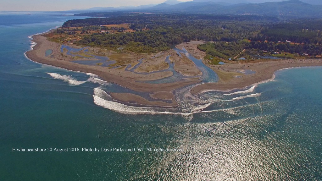
The removal of the Elwha and Glines Canyon dams began in September 2011. In the above 2015 photo, you can see the dramatic expansion of the Elwha River delta (~100 acres of new estuary habitat) and a yellow line indicating the location of the failed armoring that was littered throughout the historic Beach Lake nearshore. Not only was this abandoned armor no longer serving a functional purpose, it was impairing habitat for salmon and forage fish, in addition to interfering with sediment and wood delivery and other natural beach forming processes. It had all come full circle for this armor. First, it was put there to prevent erosion that occurred because of the dams, but after 70 years, we learned that it was not successful at preventing erosion and it was actually interfering with the beach’s ability to mend itself once the removal of the dams delivered a 100-year pulse of sediment to this shoreline.


Comparing the above 1950 and 2016 photos of this shoreline, you can see a dramatic shift from a sandy vegetated natural beach to a heavily altered beach that was littered with abandoned armor rock up to 6 feet in diameter.
In 2015, at the 9th Annual Elwha Nearshore Consortium workshop, Jamie Michel ( CWI nearshore biologist and project lead), initiated and led an interdisciplinary dialog that identified, for the first time, the direct relationship between shoreline armoring and the persistent erosion on this stretch of Elwha shoreline. And the first ecosystem restoration project of the Elwha nearshore was born. Coastal Watershed Institute approached the owner of a portion of this shoreline about their interest in a conservation sale of their property so that this stretch of shoreline could be restored to a natural beach and made available for the public to visit. The landowner was very supportive of this concept as were the U.S. Fish and Wildlife Service (USFWS), Washington State Department of Ecology, Washington State Recreation and Conservation Office (RCO) and the Puget Sound Partnership. Puget Sound Partnership designated this project, named the Beach Lake Acquisition and Restoration Project, their #1 Habitat Priority in their 2016 Puget Sound Action Agenda which is available here. In August of 2016, Coastal Watershed Institute purchased this property with funds from USFWS and RCO and immediately began the process of bringing this shoreline back to its full potential. All of this happened just in time, as the beach forming sediments made available by dam removal will only be in this stretch of shoreline for a short duration as the high wind and wave energy quickly moves sediment along this shoreline. If we had waited any longer, we may not have had the chance to allow this beach to rebuild itself naturally.


Elwha Nearshore Rising
Within just one tidal cycle, natural processes were able to deliver beach forming material (sand and wood) to the upper portions of the beach and some areas of the beach grew upwards by almost 10 feet and outwards by 20 feet. Pretty amazing how capable a natural system is of repairing itself once we get the impediments out of the way.


Dr Anne Shaffer, lead scientist at CWI, leads the monitoring efforts underway on the project.
Over 2016-2018, the project beach continued to evolve as high energy winter storms and king tides rearranged the shoreline. Portions of the newly deposited sediment were whisked away, but were just as quickly replaced by newly accumulated large woody debris (LWD). In the years when this shoreline was heavily armored, the LWD just bounced off of the armoring and was not delivered to the upper beach. LWD is a key structural component that helps create beach stability and we are excited to see that this habitat-sustaining and beach-forming feature has been naturally re-integrated into this ½ mile of shoreline as a result of dam removal and shoreline armor removal. Along the Strait of Juan de Fuca, it is common for beaches to erode in the winter and then rebuild with beach forming material delivered by alongshore transport and summer swell. The ability of a beach to retain the summer delivery of beach forming material through winter storms is greatly enhanced by the presence of LWD which helps to lattice the beach together. In the photo below, you will see that the old ‘sentinel’ snag that was an eagle perch and photo reference point has fallen over, but is now one of many new pieces of LWD on the beach.

Something else we have noticed is the re-emergence of shoreline armor that was buried within the beach last August when we conducted Phase I of armor removal. Because of the decades long legacy of failed armor attempts, we knew that this was likely to happen as buried armor ‘swam to the surface’, so the project was permitted to allow armor removal from the beach as it surfaced from 2016-2021. In 2016 we removed ~3,000 cubic yards of abandoned armor from the shoreline (~150 dump truck loads) of the estimated 8,000 cubic yards that were a part of the failed armor structure that was littered on top of and within the beach.


What Happens Next?
The upland restoration of the property is mostly complete and the site is ready for public visitation. We continue to monitor the shoreline for newly emerged armor, beach change, forage fish spawning, beach wrack, beach invertebrates and LWD. So far we have mobilized heavy equipment 14 times and have removed approximately 80% of the armor that was estimated to be littered on 2 acres of tidelands along ½ mile of the project area shoreline. Check back for more updates as they happen.

-by Jamie Michel, Project Lead